Key Takeaways
- GPS for excavators combines fleet management tracking with precision machine-control guidance, enabling operators to dig to exact specifications
- Precision-guided GPS systems achieve 1-4 inch accuracy by integrating base station receivers, roving antennas, and real-time positioning, significantly reducing over-digging and rework
- Geofencing and collision alerts protect against underground utility strikes while design file loading enables automated or operator-assisted excavation to plan specifications
- A 2012 French study showed GPS-equipped excavators reduced finishing time by two-thirds and fuel consumption by one-third, delivering substantial operational savings
- Key selection factors include accuracy requirements, compatibility with your excavator models, essential features, and ease of use for your operators
Excavation work is challenging enough without constantly worrying about underground hazards or digging to precise plan specifications. Fortunately, GPS for excavators has eliminated the guesswork. By equipping excavators with GPS systems, operators have a critical tool to make their work more productive and safer.
In this GPS for excavators guide, we'll examine everything you need to know about this topic.
- The use of GPS tracking in heavy equipment
- How GPS technology works with this machinery
- The benefits of using GPS
- GPS features and capabilities
- Selecting the right GPS system
- Installing and using GPS
- Troubleshooting GPS for excavators
- What the future holds in store for GPS for excavators
GPS: Understanding the Basics
Although GPS (global positioning system) is an everyday term, not everyone knows how this technology works. At its core, GPS works through a network of satellites orbiting the Earth, continuously transmitting their location and the current time. GPS receivers use these signals to calculate the receiver’s location on Earth based on the difference in time the signals take to reach it. Receivers can be found in phones or cars or added to equipment and other assets.
While GPS (sometimes more generically called GNSS or global navigation satellite system) is traditionally associated with navigation assistance (directions to and from a location) and item tracking, the technology takes on additional functionality with excavators: micro-precise guidance.
For instance, enhanced GPS capability can pinpoint an excavator bucket's exact location (within an inch or two) in real time. This information is analyzed by an onboard system that automates certain functions and gives additional support to the operator. All this happens via a base station GPS receiver and a supplemental receiver placed on the excavator.
Types of GPS systems for Excavators
So, in a nutshell, GPS for excavators and other construction equipment is divided into two categories:
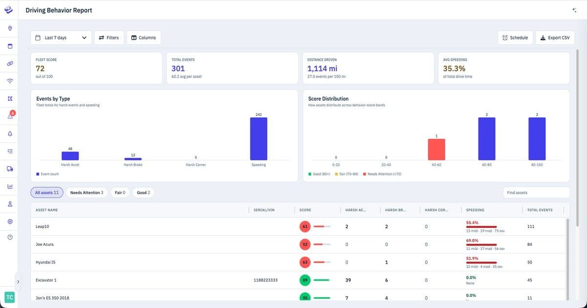
- Fleet Management: GPS to track and manage all equipment. Provides real-time data on location, usage, and performance. Helps optimize operations.
- Machine Control: GPS integrated into the excavator’s controls. Gives real-time positioning and guidance to the operator. Allows precise excavating, grading, and earthmoving.
GPS: Construction Industry Uses
Does Heavy Equipment Have GPS Tracking?
Increasingly, GPS tracking is used in heavy equipment for monitoring and management. Tracking earthmovers and other construction vehicles gives businesses real-time visibility into their assets' locations. These details maximize operations, reduce downtime, and help with asset recovery (if equipment is lost or stolen).
How GPS Technology Works on Heavy Equipment
We've already covered GPS basics, which apply to the technology's use in heavy equipment. For example, a company places a GPS device on a bulldozer or crane and can then track its position. More comprehensive GPS systems provide a platform that records an item's previous use history and can send an alert if the equipment enters or exits a predefined area (this is called "geofencing").
Does Construction Equipment Have GPS?
Any construction equipment, like a loader or grader, can be equipped with GPS. It can be tracked if it has a place to add a GPS device. The type of GPS functionality depends on the machinery and the technology. For instance, a dump truck does not need micro-precision tracking like an excavator's bucket. If the truck has GPS, it's most commonly used for tracking purposes. Machines with buckets or blades may have more advanced GPS technology to allow for precisely controlled use, such as excavating near sensitive areas. It's possible for construction equipment to have GPS for tracking and precision-use purposes.
Do Excavators Have GPS?
While not every excavator has GPS, more and more have this technology. Location-focused GPS is easily added through a battery-operated or hard-wired tracker as part of a fleet management system. Meanwhile, some excavator manufacturers, such as Caterpillar and Komatsu, offer precision-guidance GPS systems as a factory option. There are also numerous aftermarket companies.
How Does GPS Work on an Excavator?
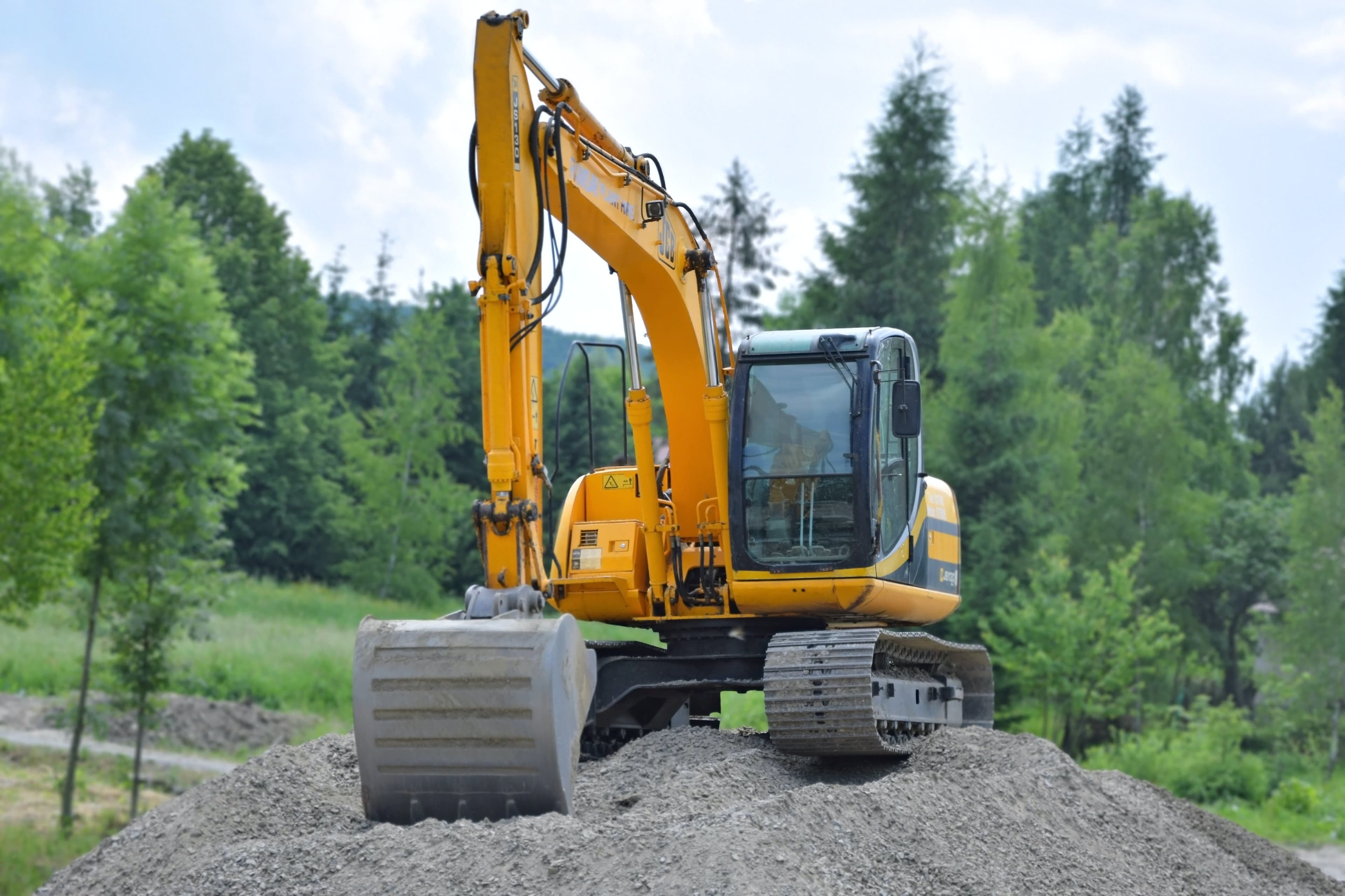
Precision-guided GPS requires adding a roving receiver antenna to the excavator, usually on the cab or boom. Sensors measure the angles of the stick, boom, and bucket cylinders to determine the precise position of the bucket’s cutting edge. The distance between the antenna and the bucket is calibrated to pinpoint the exact bucket location further.
The rover receiver connects to a base station, a GPS receiver placed at a fixed location at the job site. It serves as a critical reference point and transmits correction signals to the roving receiver.
The operator can also upload a digital topographic map of the site to the excavator’s monitor. The system has two modes: one that shows the desired cutting lines on the monitor for the operator to follow, or automation mode, where the GPS positioning guides the boom and bucket without operator assistance.
How Accurate is GPS on an Excavator?
GPS is typically accurate within 16 feet for general location and tracking purposes. Signal strength, obstructions (like buildings and trees), and other factors can affect GPS accuracy. However, GPS accuracy for precise maneuvering of an excavator is at an entirely different level. Depending on the system, GPS accuracy for an excavator bucket is often one to four inches.
Benefits of Using GPS in Excavators
It's hard to overstate the advantages for construction companies and operators when GPS is used with excavators.
Improved Efficiency and Productivity
Without GPS, excavator operators often must repeatedly check grade rods and manually adjust them to stay within project specifications. Or have someone else handle this task. This leads to slower, more disjointed work. GPS allows operators to dig precisely to the design plan’s depth, slope, and dimensions without stopping.
GPS also eliminates over-digging and rework. By following the on-screen depth and grade guidance, the operator can work confidently, knowing the bucket is digging to precisely the correct depth and slope. GPS lets operators get more work done faster. Less time on the job site means lower labor costs. It also means faster project completion for contractors.
This smooth and precise workflow translates into time and cost savings. A 2012 study by the French Institute of Science and Technology for Transport, Development and Networks (Ifsttar) determined that GPS for excavators reduced finishing working time by two-thirds. Another benefit, reports Ifsttar, is a one-third reduction in fuel consumption.
Enhanced Safety
Gas and fiber lines underground can make digging dangerous. Hitting utility lines can hurt workers and cost a lot of money. GPS systems have collision warnings that alert an operator if the excavator gets too close to mapped hazards below ground. This prevents hitting utility lines. GPS also guides operators when visibility is bad, like at night, in fog, or in dust. The accuracy of GPS helps operators work safely at any time.
Accurate Record Keeping
GPS logs all the digging work during the day and captures timestamps, depths, volumes, and locations. This data is helpful for:
- Analyzing operator performance
- Tracking production
- Customer billing
- Resolving disputes
- Improving planning and estimates
- Compliance
See How Hapn Works for Your Fleet
Get a personalized walkthrough and transparent pricing — no commitment required.
Get Pricing →GPS Features and Capabilities for Excavators
Machine-control GPS systems for excavators have many features to improve performance and productivity. These capabilities include:
- Geofencing: This sets virtual boundaries on the job site. Alerts trigger if the excavator crosses the predefined areas, keeping it within designated zones.
- Grade Control: GPS provides precision grade control for accurate excavation and grading. This is useful for projects requiring exact slopes or contours.
- Design File Loading: CAD drawings, site plans, and 3D models can load directly into the onboard computer. Operators see target depths, slopes, and dimensions on-screen.
- Anti-Collision Alerts: If underground utilities or hazards are mapped, GPS alerts before a collision occurs.
- Remote Monitoring: Fleet managers can track excavator movements and progress remotely. Metrics like idle time, fuel use, and productivity can also be measured.
- Data Reporting: Detailed logs of excavator activities, volumes, and locations are cataloged for billing, maintenance, and client reports.
Other common capabilities include wireless file transfers, material weighing, surveying equipment integration, operator guidance screens, and wear monitoring sensors.
Choosing the Right GPS System for Your Excavator
Selecting the right GPS system depends on your projects, needs, and budget. Key factors are:
- Accuracy: Look at how precise the GPS positioning needs to be. Survey-grade systems with real-time kinematic (RTK) correction provide centimeter-level accuracy for fine grading and detailed excavation work. Less accurate technology may suffice for simple trenching and excavating projects.
- Features: Determine which capabilities are the most essential for your crews and projects. Features like grade control, design file loading, remote monitoring, and data reporting add functionality but also cost. Prioritize must-have versus nice-to-have features.
- Compatibility: The system must be compatible with your excavator’s make and model. Look for plug-and-play kits or confirm extensive excavator model support from the GPS provider. Retrofitting an older excavator may require additional components.
- Ease of Use: Check that the interface, controls, and displays are straightforward for your operators to learn and use efficiently. Complex systems slow down daily work. Touchscreens and graphical interfaces can simplify guidance and control.
Talk with other excavator owners and operators to get first-hand insight into what really matters. You may find that spending a little more upfront can lead to long-term savings. At the same time, knowing what NOT to spend your money on ahead of time is helpful.
Installing and Calibrating GPS in Your Excavator
Correct installation and calibration are mandatory for a GPS system to work correctly—the manufacturer's instructions for setting up the system must be followed closely. Calibration aligns the GPS system to the excavator's specifications, matching up to boom length, bucket size, and other characteristics. This fine-tuning ensures the GPS delivers precise positioning and guidance. Taking shortcuts during setup will only lead to problems later.
Using GPS for Precise Excavation and Grading
With an integrated GPS system, excavators can easily achieve precise results. GPS systems' real-time positioning and guidance enable operators to dig to the desired depth, maintain accurate slopes, and create precise contours. This level of precision reduces rework, saves time, and enhances the overall quality of the finished project.
Common Challenges and Troubleshooting with GPS in Excavators
While GPS has many benefits, it's not a perfect technology. Here are some of the most common problems you're likely to encounter.
- Signal Interference: Be alert for tall buildings, dense vegetation, or other obstructions that can interfere with signals and affect GPS accuracy.
- Satellite Availability: Diminished GPS performance may result from spotty satellite signals. Be aware of this possibility, especially while working in fringe areas.
- Incorrect Data Interpretation: Data is only helpful to those who know how to use it. Operators require proper training to avoid misusing GPS data.
Future Trends and Advancements in GPS Technology for Excavators
Tomorrow promises a leap forward in GPS technology for excavators. Here's what the future holds:
- Artificial intelligence (AI) and machine learning to help excavators adapt to different settings and optimize routes.
- More precise RTK systems for extremely accurate digging.
- Improved connectivity with other systems through the Internet of Things (IoT)
- Augmented reality (AR) to provide operators with enriched visuals for better hazard warnings
Ready to Take Control of Your Fleet?
Join hundreds of construction and rental companies tracking smarter with Hapn.
Get Your Custom Quote →Frequently Asked Questions
Are there cameras in excavators?
Many newer excavators have cameras to improve visibility and safety for the operator. The cameras show blind spots and help with tricky moves so the operator can work more safely and efficiently.
How much does a tracked excavator cost?
The cost of a tracked excavator can vary significantly based on its size, model, age, and condition. According to Charter Capital, new large-scale excavators can range from $100,000 to $850,000. Mini excavators run $40,000 to $100,000.
How does GPS work on an excavator?
A GPS receiver is mounted on the excavator. Sensors measure the boom, stick, and bucket angles. This pinpoints the bucket location. The operator can see digging targets on the screen.
What are the main benefits of GPS for excavators?
GPS improves efficiency, safety, accuracy, and record keeping. It prevents over-digging, utility strikes, and downtime. GPS boosts productivity and reduces rework significantly.
What should I look for when choosing an excavator GPS system?
Key factors are accuracy, essential features, compatibility with your models, and ease of use. Compare systems to match your budget and needs while considering how your operators will use the technology daily.
Written by the Hapn Team — Hapn provides full-stack fleet and asset telematics for construction, rental, and field service companies. Learn more →